• Skip to main content
  • Skip to footer

INT

Empowering Visualization

CONTACT US SUPPORT
MENUMENU
  • Products
    • Overview
    • IVAAP™
    • INTViewer™
    • GeoToolkit™
    • Product Overview
  • Demos
    • GeoToolkit Demos
    • IVAAP Demos
  • Success Stories
  • Solutions
    • Overview
    • For E&P
    • For OSDU Visualization
    • For Cloud Partners
    • For Machine Learning
    • For CCUS
    • For Geothermal Energy
    • For Wind Energy
    • For Enterprise
    • Tools for Developers
    • Services Overview
  • Resources
    • Blog
    • Developer Community
    • FAQ
    • INT Resources Library
  • About
    • Overview
    • News
    • Events
    • Careers
    • Meet Our Team
    • About INT

mapping

Mar 09 2021

How to Use INTViewer 2021’s New Mapping Capabilities

INTViewer is a platform that allows geoscientists to view seismic data, check for errors, confirm geospatial integrity, perform light processing, and analyze their dataset. INTViewer is specifically designed to enable users to quickly access large datasets—prestack, stack, and 2D— from a laptop in the field to a desktop or remotely via the cloud.

The upcoming release of INTViewer 2021 has new map features including a RemoteMap plugin and support for the import and export of GeoTIFF files.

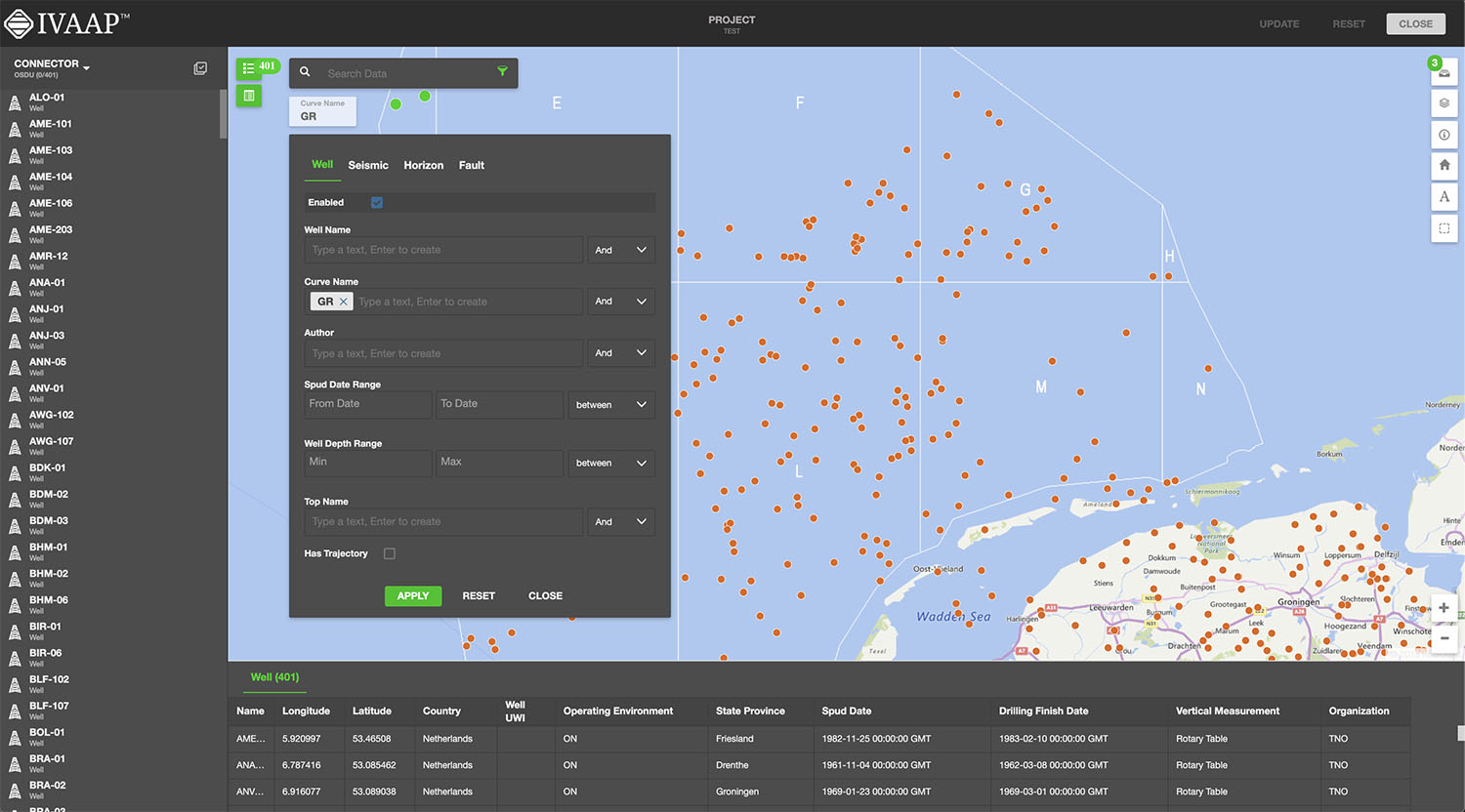
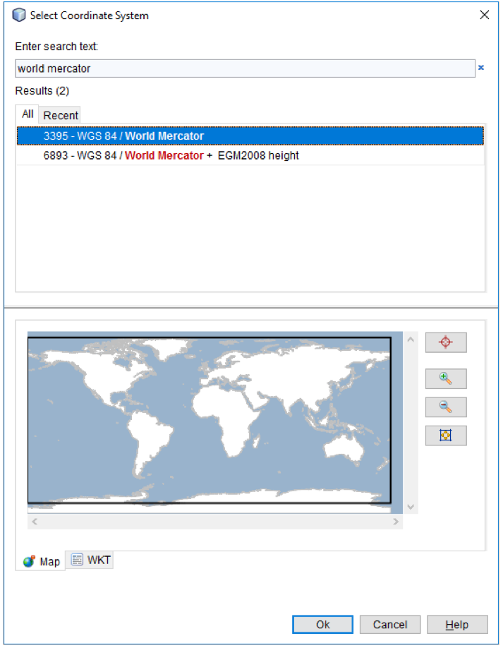
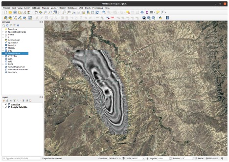
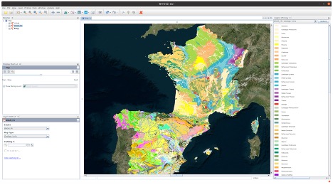
Users can populate map views with more GIS data(1). The possibility to aggregate several GIS data sources allows users to get a clear understanding of their field.

INTViewer Timeslice
Time slice exported from INTViewer and rendered on top of a satellite view in QGIS.


In the previous version of the RemoteMap plugin, users could use a Web Map Tile Service like Google or Bing to visualize in the background. In the 2021 update, we have added the possibility to set up a custom WMS server. Users can now register their preferred WMS servers in the settings panel and access them in any map view, making it easy to correlate geographic information with their data.

INTViewer Teapot Field
Teapot field, showing study bounds, lithology and faults from USGIN Geology


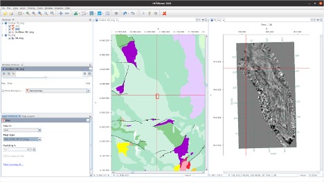
Using INTViewer, users can also produce georeferenced images by exporting maps to a GeoTIFF image to view in their favorite GIS software.

INTViewer map

With these new and improved features, users will be able to get a better understanding of their field, easily and efficiently correlate geographic data, and import and export GeoTIFF files.


For more information on INTViewer, please visit www.int.com/products/intviewer/


1 These features are available via the RemoteMap and GisRaster plugins, available on the update center.


Filed Under: INTViewer Tagged With: geotiff, gis, INTViewer, mapping, plugins, remotemap

Dec 02 2020

IVAAP Release 2.7: More Map Search and ArcGIS Features

IVAAP™ is a subsurface data visualization platform that provides developers and product owners powerful subsurface visualization features for their digital solutions in the cloud. IVAAP enables users to search, access, display, and analyze 2D/3D G&G and petrophysical data in a single user-friendly dashboard on the web. The latest release of IVAAP 2.7 comes with various new features and significant improvements.

Highlights from this release include many advanced search and map capabilities, improved 3D widget filter dialog, new interval curves support, new date/time picker for Cross-Plot widget axis settings, and more! 

Advanced Mapping Capabilities

IVAAP features support for visual-based data discovery using map-based search, and is fully integrated with ArcGIS (ESRI), allowing for the search of structured and unstructured data in a data lake or any other file repository. IVAAP supports a wide range of map formats and services like ArcGIS, GeoJSON, KML, Mapbox, Bing, WMS, and more.

With the ArcGIS integration, you can easily access all layers and details from your ArcGIS server and display them within IVAAP to enrich map-based search of well, seismic, and other subsurface data.

New features include the ability to display a dynamic metadata table for a selected object in the map (Well, Seismic, etc.). 

Most layers are supported. Image services (ArcGIS Image Service Layer, Image Services Vector Layers, and WMS) and Tile services (Image Service, ArcGIS Tiled Map Service Layer, Web Tiled Layer, OpenStreetMap) are supported. Feature Services include map service (ArcGIS Feature Layer), KML, WFS, and CSV. We also provide some real-time services support like stream services (ArcGIS Stream Layer), GeoRSS, Vector Tiles (VectorTileLayer), and Bing Maps services. Two extra formats that are supported are GeoJSON and GPX.

This release includes improved search capabilities allowing search across any metadata for any user. Access to data can be restricted to read-only mode. We also made improvements to fence highlighting and access to well lists, and labels can now be saved with the dashboard.


2_7_0_Map Reduced


More Themes Control 

Previously, theme control within IVAAP was a bit limited. We’ve expanded the theme mechanism to all widgets so that users can customize themes with more control and options and access new updated themes.


2_7_0_Customized Themes

Lightmode theme


New Image Widget 

IVAAP can now display simple image files such as jpeg or png files in the image widget, align, and zoom in to show detail. This feature allows users to customize dashboards with logos or other image files needed to display. 

Improvements in 3D

IVAAP’s 3D widget now supports tagging and aliases when displaying well data. We added reservoir data that can be serialized in the dashboard template. Users now have the ability to mix data with CRS and data without CRS. Another new feature is that users can apply properties to multiple or individual objects. And we’ve improved the dashboard restoration of multiple inlines, crossbones, and time slices. Finally, the 3D widget filter dialog has been redesigned.


2_7_0_3D Reduced


New Features in WellLog

For WellLog, we improved the set main index support for templates, dashboards, and well switching. With this improvement, a secondary index can be used to display data into a different index and secondary indexes can be restored when opening an existing dashboard or template. An improved automatic logarithmic mode gives users the ability to add a curve to a logarithmic track. New features added to WellLog include: the ability to automatically rotate labels for lithology and a reset action where users can right-click with the option to clear their display.


WellLog


New in Schematics

For the Schematics package, new features include: perforation with state definition support, the ability to customize by using a filter dialog, and the ability to use cursor tracking between Schematics and WellLog. We also improved the component selection support in the Schematics widget.


schematics 2.7


Time Series: Annotations and Perforations 

We improved the ability to select a data series from the legend. The Time Series widget now features support for annotations and perforations. The tooltip now shows the index data and time.


TimeSeries


New and Improved Line Chart

The IVAAP line chart now supports templates and data series dialog. We improved the ability to edit existing data series. Users can now flip the axis for date and time data, and the legend has been improved to show or hide the data series parent. There is also an improvement for single data sets, multi-data sets, and multi parent projects. 


LineChart


This release includes many more improvements to features and to the UI. For more information, check out the full release here.

Or check out int.com/ivaap for a preview of IVAAP or for more information about INT’s other data visualization products, please visit www.int.com or contact us at intinfo@int.com.


Filed Under: IVAAP, Uncategorized Tagged With: 3D, annotations, arcgis, CRS, ivaap, line chart, mapping, schematics, time series, welllog

Jul 21 2017

A Closer Look at Coordinate Conversions

The CRS chooser when you type “World Mercator” in the search box

INTViewer makes coordinate conversions virtually transparent to users. Users pick two Coordinate Reference Systems (CRS), one for their data and one for the visualization map, and the visualization updates automatically.

How does INTViewer do it? The short answer is “it depends”. The long answer is that the strategy used varies based upon the CRSs selected, and the points to convert. To explain this, a better understanding of CRSs is needed: Coordinate Reference Systems are essentially defined as an origin, a bounding box, and a mathematical formula to convert each point to LAT-LONG coordinates.

A well-known CRS is the Mercator projection spanning the entire globe (except the poles) and using LAT-LONG coordinates with Greenwich, UK as its origin. This CRS is known in INTViewer as “WGS 84 / World Mercator”.

There are thousands of well-known CRSs used all over the world; this is only one of them. The European Petroleum Survey Group (EPSG) was formed in 1986, and maintains the list of these CRSs. This group provides a database of CRSs to all subscribers and this database is exported in the form of XML files to INTViewer. When you pick a CRS, you are essentially going through that exported list of CRSs.

When INTViewer converts coordinates between two CRSs, one strategy is to use WGS 84 as a hub. This means that we first convert coordinates from the first coordinate system to the WGS 84 coordinate system, then we convert the resulting coordinates to the second coordinate system. Unfortunately, this cannot be done with the CRS definitions alone; a “transform to WGS 84” needs to be specified for the conversion to WGS 84.

WGS 84 as a transformation hub


By default, INTViewer doesn’t prompt for that transform even where there are several possible options. INTViewer picks the transform to WGS 84 automatically based upon the bounding box of the points to convert. Each transform has its own “area of use” and INTViewer tries to pick the transform that has the smallest area of use but still contains all points to convert.

The CRS options panel


Users can elect to pick transforms manually by checking the highlighted option in the CRS options panel.

The “WGS 84 hub” technique is an easy way to convert coordinates between any two CRSs, but this is not the most accurate method, as it can introduce errors of more than 10 meters. For really accurate conversions, NADCON (North American Datum CONversion) and NTV2 (National Transformation Version 2) grids are a better option.

In a few words, NADCON and NTV2 grids allow much more precise conversions between two CRSs that have overlapping bounding boxes. NADCON and NTV2 grids are not defined for the entire planet, only specific areas of interest like North America, Europe, Australia, or the Middle East. As a result, INTViewer will use the WGS 84 technique as a fallback only if NADCON or NTV2 grids are not defined.

North America typically uses two different datums: NAD27 and NAD83. NAD27 and NAD83 are two geodetic reference systems, one created in 1927, the other in 1983. In 1989, U.S. states started defining High Accuracy Reference Networks (HARN) using GPS technology, making it possible to convert coordinates to LAT-LONG without a loss of precision of more than one meter. To take advantage of this precision, INTViewer attempts to use HARN-based conversions when possible.

In conclusion, the strategy to convert coordinates is highly based on the area of use (the bounding box) of the points to convert. If these points are found to be outside of a NADCON or NTV2 area, WGS 84 will be used as a hub. HARN may be used within the NADCON areas.

INTViewer has been evaluated against the OGP Geospatial Integrity of Geoscience Applications (GIGS) compliance guidelines and found to be compliant in 2013. The International Association of Oil&Gas Producers (OGP) created these guidelines to eliminate common failures of geospatial integrity in geoscience software applications.

While not a pure mapping software, INTViewer tries to find the right mix between ease of use and accuracy. The accuracy is good enough that it can be used to manage exclusion zones in seismic data, as demonstrated by the Mineral Rights plugin. As a developer, you can leverage this conversion mechanism in your own plugin without worrying about the implementation details.

Check back soon for more new features and tips on how to use INTViewer or contact us for a demo.


Filed Under: INTViewer Tagged With: CRS, INTViewer, mapping

Footer

Solutions

  • For E&P
  • For OSDU Visualization
  • For Cloud Partners
  • For Machine Learning
  • For CCUS
  • For Geothermal Energy
  • For Wind Energy
  • For Enterprise
  • Tools for Developers
  • Customer Success Stories

Products

  • IVAAP
  • GeoToolkit
  • INTViewer
  • IVAAP Demos
  • GeoToolkit Demos

About

  • News
  • Events
  • Careers
  • Management Team

Resources

  • Blog
  • FAQ

Support

  • JIRA
  • Developer Community

Contact

INT logo
© 1989–2023 Interactive Network Technologies, Inc.
Privacy Policy
  • Careers
  • Contact Us
  • Search

COPYRIGHT © 2023 INTERACTIVE NETWORK TECHNOLOGIES, Inc