Meet Our Summer Interns!
Four talented and motivated students have recently joined the INT team to be a part of our Summer Internship Program. The program provides an exciting […]
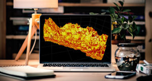
GeoToolkit.JS: New Features and Improvements in Carnac 3D
The Carnac3D module is part of the GeoToolkit.JS library and utilizes WebGL 2.0 technology for 3D rendering on web browsers. For those who are not […]
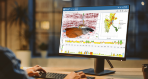
Improving Seamless Visualization and Embedding Dynamic Visualization with IVAAP 2.9
Companies in the energy industry face several challenges when it comes to streamlining large datasets, finding compatibility among applications, and visualizing different types of data […]
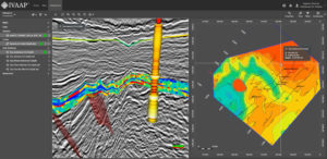
INT Advances IVAAP as Universal Subsurface Cloud Viewer with Full OSDU™ Data Platform Support
Empower energy users’ experience by embedding advanced subsurface data visualization with your data science in your digital solutions. INT, a leading provider of data visualization […]

Rethinking ML Integration to Deliver a User Experience with a True End-to-End Geoscience Workflow
For E&P companies, the next challenge in their digital transformation — once their data has been properly stored, indexed, enriched, and cataloged in the cloud […]